Contents
- 🎵 Origins & History
- ⚙️ How It Works
- 📊 Key Facts & Numbers
- 👥 Key People & Organizations
- 🌍 Cultural Impact & Influence
- ⚡ Current State & Latest Developments
- 🤔 Controversies & Debates
- 🔮 Future Outlook & Predictions
- 💡 Practical Applications
- 📚 Related Topics & Deeper Reading
- Frequently Asked Questions
- References
- Related Topics
Overview
The Karakoram's geological genesis traces back to the titanic collision of the Indian Plate with the Eurasian Plate, a process that began approximately 50 million years ago during the Cenozoic Era. This ongoing tectonic activity continues to uplift the range, making it one of the most seismically active regions globally. Early human interaction with the Karakoram was primarily through ancient trade routes like the Silk Road, which skirted its northern flanks, connecting Central Asia with the Indian subcontinent. Historical records from the 1st millennium CE mention formidable mountain passes, though detailed exploration by outsiders only began in the 19th century with figures like Francis Younghusband and the Great Game surveyors mapping its vastness.
⚙️ How It Works
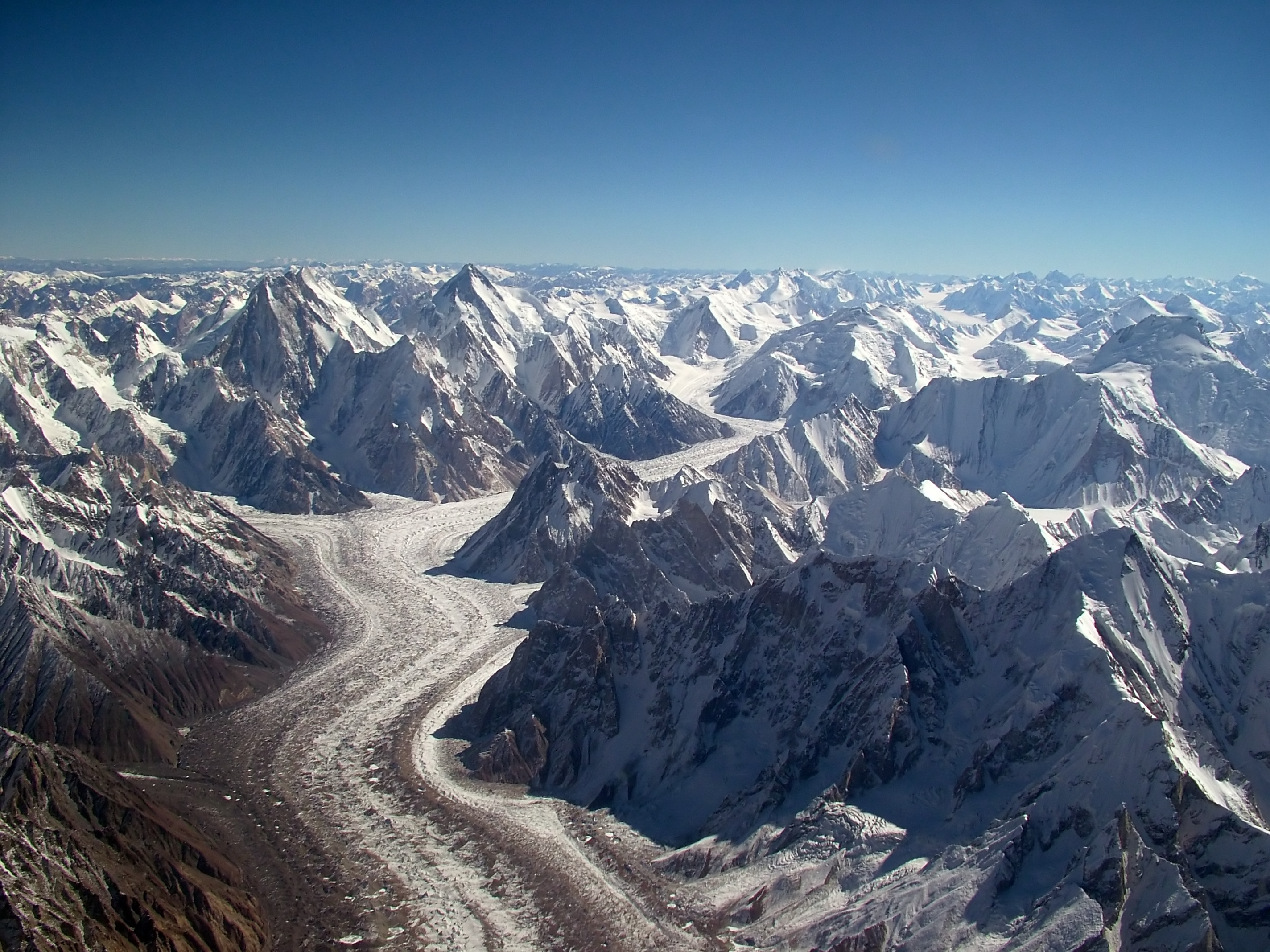
Geologically, the Karakoram is a complex mosaic of metamorphic, sedimentary, and igneous rocks, primarily granites and gneisses, thrust upwards by immense compressional forces. Its 'working' mechanism involves continuous plate tectonics, where the Indian Plate subducts beneath the Eurasian Plate, causing intense folding, faulting, and volcanism, though the latter is less prominent here than in other collision zones. The range is characterized by a high concentration of very large glaciers outside the polar regions, such as the Siachen Glacier and the Biafo Glacier, which act as massive ice rivers, carving valleys and shaping the landscape. These glaciers are fed by heavy snowfall, often exceeding 10 meters annually at higher elevations, and play a crucial role in regional hydrology, feeding major rivers like the Indus River.
📊 Key Facts & Numbers
The Karakoram Range boasts four of the world's fourteen 'eight-thousanders' (peaks over 8,000 meters), including K2 (8,611 m), Broad Peak (8,051 m), Gasherbrum I (8,080 m), and Gasherbrum II (8,035 m). It contains over 60 peaks exceeding 7,000 meters (23,000 feet). The range is home to the longest glaciers outside the polar regions, with the Siachen Glacier stretching approximately 76 kilometers (47 miles) and the Baltoro Glacier extending 63 kilometers (39 miles). Annual precipitation varies drastically, from less than 100 mm in the arid valleys to over 1,000 mm at higher altitudes, primarily as snow. The average elevation of the range is around 5,500 meters (18,000 feet), making it one of the highest mountain systems globally.
👥 Key People & Organizations
Key individuals and organizations have shaped our understanding and interaction with the Karakoram. Early explorers like Henry Haversham Godwin-Austen, who surveyed K2 in 1856, provided foundational geographical knowledge. Mountaineering legends such as Reinhold Messner, the first to climb all 14 eight-thousanders, and Walter Bonatti, known for his epic K2 ascent, pushed the limits of human endurance. Organizations like the Alpine Club and the American Alpine Club have sponsored expeditions and research. The Pakistan Army and Indian Army maintain a significant presence, particularly around the Siachen Glacier, due to ongoing territorial disputes, making them key actors in the region's human geography.
🌍 Cultural Impact & Influence
The Karakoram has profoundly influenced the cultures of Gilgit-Baltistan in Pakistan and Ladakh in India, fostering unique linguistic groups like the Balti people and Burusho people, whose traditions are deeply intertwined with mountain life. Its formidable passes, like the Khunjerab Pass, have historically facilitated limited but vital trade and cultural exchange along the Karakoram Highway, connecting Pakistan and China. In popular culture, the range is often depicted as a symbol of extreme wilderness and adventure, featuring in documentaries like 'Sherpa' and inspiring countless books on mountaineering, such as 'Into Thin Air' by Jon Krakauer, though his focus was primarily on Everest, the spirit of high-altitude challenge resonates.
⚡ Current State & Latest Developments
In 2024-2025, the Karakoram remains a focal point for climate change research, with studies from institutions like the University of Zurich monitoring its 'Karakoram Anomaly' – a phenomenon where some glaciers are stable or even advancing, contrary to global trends, though the long-term outlook is still uncertain. Geopolitically, the region is highly sensitive, with ongoing tensions between India and Pakistan over Kashmir and the Siachen Glacier, and China's increasing infrastructure development, including the China-Pakistan Economic Corridor (CPEC), which traverses the range. Mountaineering expeditions continue, with recent winter ascents of K2, like the 2021 success by a Nepali team, pushing the boundaries of human achievement.
🤔 Controversies & Debates
The Karakoram is rife with geopolitical controversies, primarily the Siachen Conflict between India and Pakistan, which has been ongoing since 1984, making it the highest battlefield in the world. Both nations maintain thousands of troops in conditions that claim more lives from frostbite and avalanches than direct combat. Environmental debates center on the impact of increased tourism and infrastructure projects, like the Karakoram Highway, on fragile ecosystems and indigenous communities. There's also scientific debate regarding the 'Karakoram Anomaly' and its implications for global climate models, with some researchers at the ICIMOD questioning the long-term sustainability of this glacial stability.
🔮 Future Outlook & Predictions
The future of the Karakoram is poised between increasing accessibility and environmental preservation. With the expansion of the China-Pakistan Economic Corridor, more infrastructure is expected, potentially boosting trade and tourism but also increasing ecological pressure. Climate models from the Max Planck Institute predict continued glacial retreat in the broader Himalayan region, though the Karakoram's unique anomaly might persist for decades, offering a crucial natural laboratory for glaciologists. Geopolitical tensions are unlikely to fully dissipate, meaning the range will remain a strategic flashpoint, with both military and scientific communities closely monitoring developments through 2030 and beyond.
💡 Practical Applications
Beyond its role in climate science and geopolitics, the Karakoram offers practical applications in adventure tourism, attracting thousands of trekkers and mountaineers annually to destinations like Hunza Valley and the K2 Base Camp. Its vast ice reserves are a critical source of freshwater for millions in downstream regions of Pakistan and India, supporting agriculture and hydroelectric power generation. The Karakoram Highway serves as a vital economic artery, facilitating trade between China and Pakistan, transporting goods and fostering regional economic integration. Furthermore, its unique biodiversity, though sparse, provides a natural laboratory for high-altitude biology and conservation efforts by groups like the World Wildlife Fund.
Key Facts
- Year
- Ongoing
- Origin
- Asia (Pakistan, China, India, Afghanistan, Tajikistan)
- Category
- nature
- Type
- place
Frequently Asked Questions
What is the highest peak in the Karakoram Range?
The highest peak in the Karakoram Range is K2, also known as Mount Godwin-Austen, which stands at an elevation of 8,611 meters (28,251 feet) above sea level. It is the second-highest mountain in the world, surpassed only by Mount Everest. K2 is renowned for its extreme difficulty and high fatality rate among climbers, earning it the nickname 'Savage Mountain,' with statistics from the American Alpine Journal indicating a summit-to-death ratio significantly higher than Everest.
Why is the Karakoram Range considered a geopolitical hotspot?
The Karakoram Range is a significant geopolitical hotspot primarily due to the unresolved territorial disputes between India and Pakistan over the Kashmir region, particularly the Siachen Glacier. Since 1984, both nations have maintained military outposts at altitudes exceeding 6,000 meters (20,000 feet), making it the highest battlefield globally. Additionally, China's increasing presence and infrastructure development, such as the China-Pakistan Economic Corridor (CPEC) through the Karakoram, add another layer of strategic complexity, as detailed by analyses from the Council on Foreign Relations.
What is the 'Karakoram Anomaly' and why is it significant?
The 'Karakoram Anomaly' refers to the unusual phenomenon where many glaciers in the central Karakoram are stable, or even advancing, while most glaciers globally are retreating due to climate change. Research published in journals like 'Nature Geoscience' suggests this might be due to increased winter snowfall, reduced summer temperatures, or unique topographical features that trap moisture. This anomaly is significant because it challenges simplistic global climate models and provides a crucial natural laboratory for glaciologists to understand complex glacial dynamics, as highlighted by studies from the University of Potsdam.
How does the Karakoram's geology contribute to its extreme landscape?
The Karakoram's extreme landscape is a direct result of its geology, specifically the ongoing collision between the Indian Plate and the Eurasian Plate. This immense compressional force has uplifted massive blocks of crust, creating sharp, jagged peaks and deep, narrow valleys. The presence of hard, resistant rocks like granite and gneiss, combined with rapid erosion by glaciers and rivers, carves out the dramatic, high-relief topography. This continuous tectonic activity, documented by the US Geological Survey, also makes the region prone to earthquakes and landslides, further shaping its rugged character.
What are the main challenges for mountaineers in the Karakoram?
Mountaineers in the Karakoram face unparalleled challenges, primarily due to extreme altitude, severe weather, and technical climbing difficulties. Peaks like K2 are notorious for unpredictable storms, high winds, and temperatures plummeting below -40°C (-40°F). The terrain often involves steep rock and ice faces, requiring advanced climbing skills and extensive use of fixed ropes. The sheer remoteness and logistical complexities, including long approaches to base camps and limited rescue capabilities, further amplify the risks, as chronicled in numerous accounts by climbers like Ed Viesturs and organizations like the Alpine Club of Pakistan.
What role does the Karakoram Highway play in the region?
The Karakoram Highway (KKH), often called the 'Eighth Wonder of the World,' is a 1,300-kilometer (800-mile) road connecting Pakistan and China through the Khunjerab Pass at 4,693 meters (15,397 feet). It serves as a vital economic artery, facilitating trade, tourism, and cultural exchange between the two nations. Constructed over two decades, primarily by the Pakistan Army Engineers and Chinese engineers, it is a marvel of engineering through treacherous mountain terrain, crucial for the China-Pakistan Economic Corridor (CPEC) and regional development, as highlighted by reports from the Asian Development Bank.
How do climate change projections affect the Karakoram's future?
While the 'Karakoram Anomaly' suggests some glacial stability, long-term climate change projections for the broader Himalayan region from the IPCC indicate overall warming trends. This could eventually impact the Karakoram's glaciers, leading to increased meltwater runoff in the short term, potentially causing glacial lake outburst floods, and then reduced water availability in the long term for downstream populations. The unique microclimates and high elevations of the Karakoram might offer some buffer, but sustained global warming will inevitably exert pressure on its ice reserves and fragile ecosystems, necessitating continuous monitoring by institutions like the Pakistan Meteorological Department.